

Omnivias Platform
An architecture built for critical operations
Computer vision models, distributed processing, data, events, dashboards and integrations in a platform that evolves with the highway. Video processing, data consolidation and the operator experience are kept separate to scale efficiently, and each local server keeps operating without the central site.
From the camera to the control center
| Layer | What it does | Where it runs |
|---|---|---|
| Cameras | Existing fixed and PTZ cameras provide the video (RTSP/ONVIF). | On the highway |
| Inference | NVIDIA GPU servers analyze the video and apply SAT and DAI rules. | Close to the cameras (toll plazas, technical rooms) |
| Central services | Consolidate events, users, databases, images, APIs and analytics. | On premises, cloud or hybrid |
| Interface | Camera wall, map, alerts, statistics and reports for the operator. | Web browser, in the control center |
| Integration | REST APIs, webhooks, Digifort, Kria and connectors. | Between Omnivias and the control center ecosystem |
Capabilities in production
Beyond SAT and DAI, what already runs on the highways we serve.
Camera wall and map
Live, with the latest events highlighted and their location on the road section.
Text search in video
Find recorded scenes by describing what you are looking for, such as “truck on the shoulder”.
License plate recognition
Plate reading for lookups, lists and passage records.
Zone editor by preset
Lanes, shoulder, counting lines and direction drawn per camera and per PTZ position.
False alarm report
By camera and by event type, to calibrate where a rule gets it wrong.
Camera health
Camera offline, view blocked or out of position, with automatic camera recovery.
Analyze uploaded video
Upload a recorded file and generate alerts and statistics from it.
Autonomous operation
Each local server keeps analyzing and storing events even without the central site.
Continuous model improvement
Footage from the highway itself strengthens the models throughout operation.
See the platform in action, no sign-up
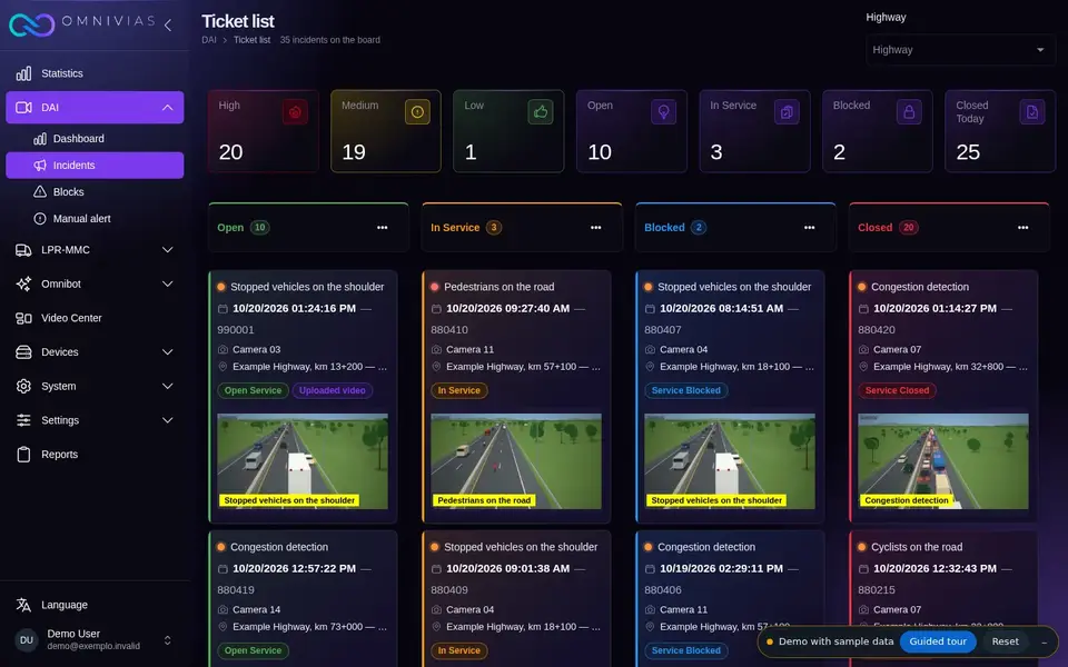
The demo is the same product that runs in traffic operations centers, with sample data generated in your browser. No client footage, no login.
On-premises, cloud or hybrid
The architecture is defined by camera volume, connectivity, latency, security, retention and IT standards. In every case, each local server keeps operating on its own if the link to the central site drops.
Integration without lock-in
Omnivias can be the main interface or an intelligence layer connected to the existing Traffic Operations Center.
- Digifort
- Kria
- REST APIs
- Webhooks
Frequently asked questions
Where is the Omnivias platform installed?
On premises, in the cloud or in a hybrid model. The architecture is defined by camera volume, connectivity, latency, security, retention and the operation’s IT standards.
What happens if the connection to the central site drops?
The inference servers close to the cameras keep analyzing video and storing events. When the connection returns, the data is consolidated at the central site.
Does Omnivias work with PTZ cameras?
Yes. Analysis zones are drawn per camera and per PTZ position (preset), and the platform takes the camera’s current position into account.
How do I find a scene in recorded video?
With text search in video: the operator types what they are looking for, such as “truck on the shoulder”, and the platform returns the recorded scenes that match the description.
Can I analyze a recorded video?
Yes. A video file uploaded through the interface goes through the same processing as the cameras and generates alerts and statistics.
Start with a pilot on your own cameras
First we assess the cameras the highway already has; then a proof of concept using footage from the road section itself shows the measured result. Depending on the size of the project, the assessment and the proof of concept can be free of charge, and the proof of concept starts running within 10 days of signing the agreement.
Assessment
Resolution, position, coverage, lighting and network of the existing cameras, against what the operation wants to measure and detect.
Proof of concept
SAT and DAI running on footage from the road section itself, measured against the agreed success criteria.
Production
On-premises, cloud or hybrid architecture, control center integration, rules, alerts and reports.
Continuous calibration
Rules and models tuned camera by camera using the real alert history.
Tell us about your operation
Share your current infrastructure, the challenges on your road section and the goal of the assessment. The Omnivias team joins the conversation with context and proposes a pilot using footage from your own highway.
- Phone and WhatsApp
- +55 11 3636-8989
- Address
- São Paulo, SP, Brasil